Wednesday, August 29, 2012

Berg Lake Trail - Day 4

Day 4 dawned, and we were up early - today was the big test.  After a few consecutive days of hiking, how would we fare on a 23km hike with full packs? Especially with knees that weren't getting any younger...  We had eaten all we could to lighten the load, but that only helped so much.


Ready to depart!

Making good time as we passed the Berg Glacier and blew through the flats

Emperor Falls heralded the steepest downhill and loosest footing, requiring care

Looking down onto the plain containing Kinney Lake

Was it really this snakey and steep on the way up?

Well, we rocked it.  We left just before 8:15am, and including breaks for snacks, a full lunch, and photos, we were at the trailhead just a hair after 2:30pm.  I have to say, I was extremely impressed by Sarah's performance - she was practically running the whole way, until the last few kilometres - a really phenomenal feat, especially for someone unused to the feel of a heavy backpack.  Way to go Sarah!

Not only that, but against all odds - and certainly owing to the great weather and unbeatable scenery - I think I've converted Sarah into a fan of backpacking.  Who knew?

We did it!  On the bridge at the trailhead

Grrr, don't mess with S Fro!

Arrrgh, you want some more of that?

We spent a well-deserved night at a room in the nearby, rustic Mt. Robson Lodge, and watched a huge rainstorm roll through for all of that afternoon, night and the next morning.  Our timing was perfect.  We even rewarded ourselves with a "nice" meal at the Caribou Grill in Valemount, since we had spent out first wedding anniversary on the Berg Lake Trail.  (Fitting, given that we got engaged on a hike too.)  Though our general recommendation would be, if you don't have to eat in Valemount, don't.  The prospect of two long days spent sitting on our butts and driving across the province sounded good at this point.

Berg Lake Trail - Day 3 (Snowbird Pass)

Day 3 was Snowbird Pass Day!  This is a 19km day hike from our campsite, featuring 700m of elevation gain to a pass at 2408m (7900 feet) which looks out over the Reef Icefield.  We were told not to miss it, so despite tired legs, we took comfort in our light day packs and set out around 8:30am again (so we would not be caught by mid-day heat on the walk up, or afternoon showers on the walk back).

Chad channels his inner Karate Kid at the start of the trail.  Robson Glacier in background

Sarah surveys the trail and river

The Robson Glacier is receding quickly.  It is now at least 1.5 km past this sign - where it was 100 years ago

After skirting Robson Lake to the left, we began a very gentle ascent of the lateral moraine of the Robson Glacier, with Rearguard Mountain across the valley from us.

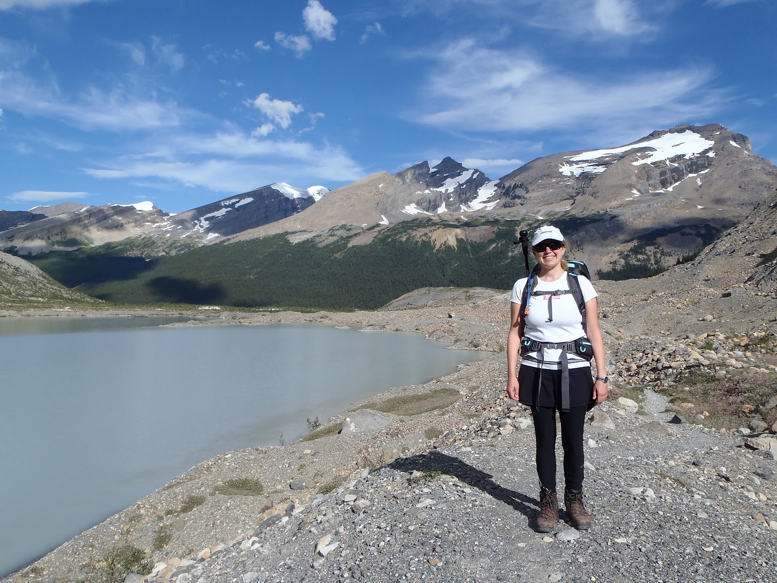
Looking back towards our campsite.  Sarah is outfitted and ready

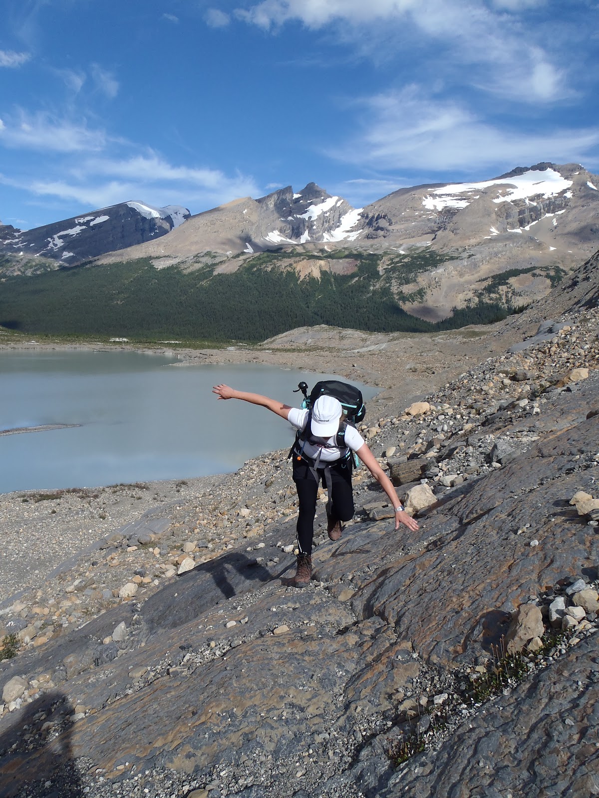
Sarah displaying characteristically cat-like reflexes as the mountain tries to trip her.  It did not succeed

Chad marching along the moraine

Don't worry, we'll stay off the glaciers...

Just after the above sign, the trail took a dramatic turn uphill and got very steep and a bit rough.  The previous days of hiking caught up with Sarah at this point, so rather than further exhausting her legs she took the prudent course and turned back, saving her energy for the very significant 23km hike with full pack the following day.  Chad pressed on, with the promise of photos from the top.

The Robson Glacier begins to reveal more of itself

View of Rearguard Mountain and Robson Lake, with Robson Pass on the right side of the treed area

The trail definitely got interesting, including this little section hugging a cliff that had some chain fences for comfort.  Very fun, though you had to pay attention to avoid losing the trail in some places.

I'm pointing at a ridge only a few feet in front of me, followed by a steep drop.  The valley bottom and glacier are hundreds of metres below

Glacial ice

Moraine-top trail

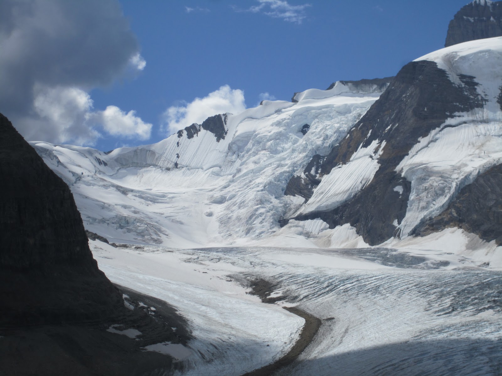
The trail leveled off for a couple of kilometres, and ran along the top of the Robson Glacier's lateral moraine. Geologically interesting - the hill above on the left was a loose rock slope resulting from erosion - sedimentary-type rocks had broken off in big, rectangular slabs.  But the glacier, during its prime, had pushed the material I was walking on all the way up to this height - it was round rocks, gravel and sand below me and on the downhill slope to the right.

Trail turned uphill again at this waterfall, which drops into the valley below

Alpine meadow

Once over the lip of the cliff, the trail flattened out nicely and wound through a surprisingly lush alpine meadow, full of grasses and flowers.

Looking back, the north face of Mt. Robson and the meadow

After meandering through some grassy bowls, the trail hits pure, lifeless alpine and heads up a loose, rocky slope to the pass.

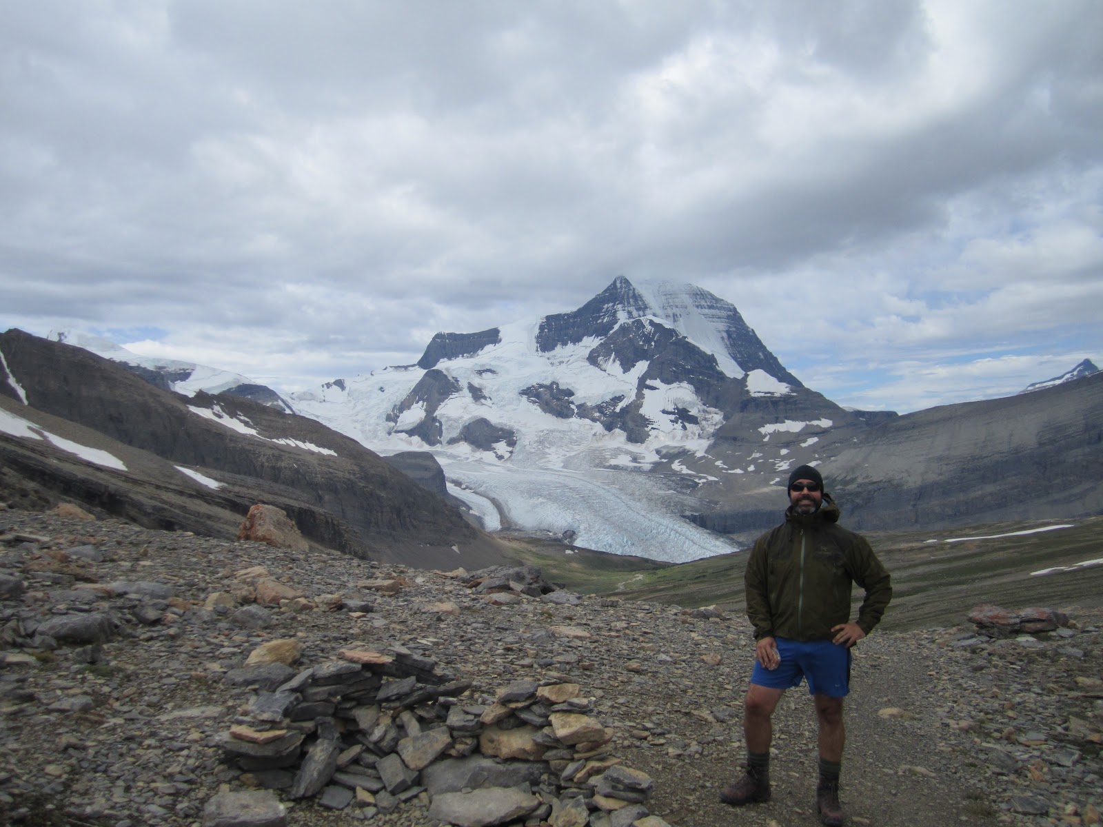
Feeling good, approaching Snowbird Pass (in background)

Snowbird Pass!  It was damned windy, so I was glad to have brought my toque and jackets.

At Snowbird Pass, looking back towards Mt. Robson

And man, was it worth the climb...

Looking out over the massive Reef Icefield, to the right of Snowbird Pass

Looking to the left of Snowbird Pass, over the Reef Icefield.  I'm blocking the view of the Colemand Glacier

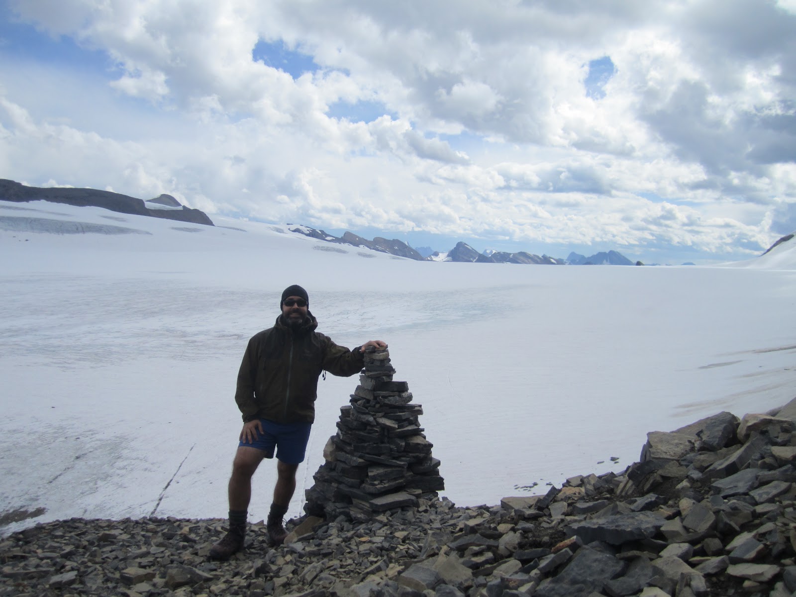
That view was spectacular.  The Reef Icefield is huge - it must be many kilometres across, and potentially dozens long (it disappears over the horizon to the right).  I spent about 50 minutes at the pass, having lunch and taking in the view.  There's no good way down the other side of the pass (it's a steep drop-off), and even if you did make it down, crossing the glacier would require expert knowledge and skills, even if it was safe enough.  So it felt like reaching the top/the end of the line, which was satisfying.

I took a brief panorama movie that might or might not give a better idea of the grand scale of the icefield, below.


Looking left from the pass

Zoomed in view to the left of the pass

Zoomed in view to the right of the pass.  The mountains beyond the icefield seem rugged and endless

Looking up the very loose scree slope from my viewpoint

The short path up to the viewpoint from the pass, with Mt. Robson and Rearguard Mountain in the background

Mt. Robson, as seen from near Snowbird Pass

On the way down, I came across (almost stepped on) a smallish but very unafraid and curious marmot.  He seemed not to have any natural enemies up this high.  Though a young German woman from our campsite claimed to have seen three wolves on the Snowbird Pass trail (who could have been hunting marmots), though that seems unlikely given that the trail is busy, no one else saw them, and food and camouflage are sparse at those elevations.


Mt. Robson and meadows

Rearguard Mountain and creek bed

Upper reaches of Robson Glacier

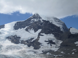
North Face of Mt. Robson

One of the people in our campsite was an elite mountaineer back in the 1980s - apparently he summited Mt. Robson and nearby mountains many times.  He said that back in the 80s, the whole north face was snow and was much easier to climb.  Now, there is a ton of exposed rock and "fan" marks from huge chunks of falling ice and rock.  He said he would never climb that face now, as it's too dangerous.  He also mentioned how the early climbers (early 1900s) had it a lot easier (apart from their equipment/technology), as they simply walked up the Robson Glacier (which was much bigger and safer), then over a snow-covered couloir onto the shoulder of Robson, then a quick final push to the summit.  The glacier is now a mess of crevasses and such, so you have to walk around most of its lower reaches now.


After a truly fantastic day hike, I went for another dip in Adolphus Lake (a bit chillier than the previous day), followed by a great meal with our friendly camp mates.


The two guys on the left are long-time friends from Edmonton who go out into the backcountry a couple of times a year together, as it's their favourite thing to do.  The guy on the right is originally from Sarajevo (he emigrated before Yugoslavia dissolved) and was super nice, in addition to being a classic solo outdoorsman, complete with Rambo-style bowie knife and headband.  It was really nice to have a fire and some good conversation before our big hike out the next day.

Berg Lake Trail - Day 2

The next day dawned clear again.  Knowing that we had a long, steep uphill ahead of us (500m over only a few kilometres of trail), we wanted to get on the trail before the sun poked its head over the mountain and started heating things up.  So we were on the trail by about 8:30am.

Packing up camp

Camp is packed, and we are ready to rock

Sarah balancing well on the first bit of trail.  Note the sun hasn't reached the valley yet


Ah, and then comes the uphill, ending just after Emperor Falls.  Slow and steady.  I'm in the middle of the photo, and yes that's the trail I'm on.

The top end of White Falls

Falls of the Pool

Happy to be hiking in such nice country

Chad looks towards Emperor Falls

Chad and Sarah wave from in front of Emperor Falls

In late morning, having climbed most of the uphill, we took a break at Emperor Falls.  The meltwater from the Robson, Berg and Mist Glaciers all pours down here, where much it hits a rock partway down and shoots outward in a jet of mist before flowing all the way down to the trailhead and shortly thereafter joining the headwaters of the Fraser River.  It's really impressive - loud and huge.  If you step into the main mist jet, you get soaked instantly.

Mist from the falls

The amount of mist and wind generated by the falls was impressive, as may be seen in the below video clip.


A bit more uphill, and then the path clung to the middle of a loose, rocky slope that skirted the floodplain below.  Many pikas (like a cross between a mouse and a rabbit) whistled at us from among the rocks.  We could see the Mist Glacier in the distance, an impressive example of things to come.

Mist Glacier in the distance

Mist Glacier behind its moraine, with part of the north face of Mt. Robson above.

Big flood plain/slide area, with Berg Glacier in the distance, right

Soon the trail let out onto a large plain that was clearly the result of slides and floods - all round stones and gravel and sand.  Just beyond it was Berg Lake and the Berg Glacier - so named because the glacier calves off pieces of ice into the lake that form small icebergs.


Hargreaves Shelter at Berg Lake Campground

After winding around the lake for quite a while, we finally came to Berg Lake Campground, the biggest & most popular stop on the trail.  It has a huge, glass-windowed shelter, but a few too many people to make it feel like you're truly in the backcountry.  We stopped for lunch on the lawn with a great view of the lake and Berg Glacier before heading onward to our campsite - Robson Pass, the furthest one in the park.

Sarah takes a water break - looking back the way we came, Berg Lake in the distance.

Ranger Cabin near our campsite had a swimming-pool-like  stream outside, complete with island, as well as a seated campfire area and horseshoe pits.  But again, no one was home.  And we could have house-sat!

Our tent at Robson Pass campsite, with the Robson Glacier in the background (which spills down from the north face of Mt. Robson) - only visible from our campground and beyond

I am liking this!

Start of the trail to Snowbird Pass, which we would tackle the next day

After the day's 12km hike, we though we would stretch our tired legs with a little walk - to Alberta!  Robson Pass campsite is only about 1/2 a kilometre from the Alberta (and Jasper National Park) border, thought it's not much of a pass - you might gain 10 feet of elevation before hitting the Great Divide, but that was fine with us!

Welcome to Jasper National Park and Alberta

And on the other side, welcome back to Mt. Robson and British Columbia

Sarah feeling pumped after all that elevation gained, as diagrammed on the left

Chad straddles two parks, two provinces, and the Great Divide, all at the same time

Meadows/valley bottom near Robson Pass campsite were covered in these cotton-like grasses

A little wade in Adolphus Lake

Just inside Jasper a couple of hundred metres is Adolphus Lake.  It's only indirectly fed by glaciers (though streams), and since it's also shallow and it had been really sunny for a few days, it was perfectly swimmable. A great way to cool off after a day of hiking.  (Some people were swimming in Berg Lake, but that's more of a polar bear dip.)


Sunset on Rearguard Mountain, with Mt. Robson behind it.  Perspective is deceiving; Mt. Robson is 1.2 kilometres higher than Rearguard
In the deep twilight, one of our camp mates pointed out a porcupine who was climbing a tree in our campsite.  It looked like a huge, furry, slow-moving cat.  We had heard stories from other hikers about the porcupine, and how it would eat the handles of your walking sticks it you left them out.  While it was claimed he was after the salt/sweat in the handles, we figured it was more likely because he was after the rubber (since we heard porcupines apparently will chew on things like car tires, given the chance).

We fell asleep to a couple of light mountain showers again (summer weather near Robson is usually morning sun & cloud, with patchy showers in the late afternoon and evening).  But it was a great sleep after another great day filled with exercise, fresh air and unbelievable views.